
Abstract
Keywords
Introduction
Smart cities build on the idea of collecting data about the city in order for city administration to be operated more efficiently. Integral to this is the deployment of sensors to measure and record various aspects of the everyday life of cities. By proponents of smart cities, this is often presented as a ‘new’ science of social physics, a view that however has been criticised for ignoring the longer history of quantification and positivism (Barnes, 2013; Barnes and Wilson, 2014). Much research has interrogated the discourses that underpin the development of smart cities (Grossi and Pianezzi, 2017; Hollands, 2015; Kitchin, 2015, 2021; Söderström et al., 2014; Wiig and Wyly, 2016). Other scholars have called for research into the functioning of actually existing smart cities (Shelton et al., 2015) and how existing inequalities are reinforced and new inequalities are created in these (Cardullo and Kitchin, 2019; Harrison, 2017; Robinson and Franklin, 2021; Vanolo, 2014, 2016). Recently, there have been calls to explore new ways of approaching the study of smart cities through the digital artefacts that they produce (Burns and Wark, 2020). While some critical attention has been paid to the objects that are expected to carry out the collection and processing of massive amounts of data about the city, that is, the sensors (Gabrys, 2007, 2014, 2016, 2019a, 2019b, 2019c; Houston et al., 2019; Pritchard et al., 2018), it is further need to explore the technologies that produce the smart city. In this paper, we turn our attention to subscales of the urban that are often overlooked in the critical interrogation of smart cities by exploring how sensors are involved in the production of smart city spaces.
Within a research project gathering an interdisciplinary team of researchers – engineers, designers, gender scholars and human geographers – we have been working together using participatory design approaches to explore how paying attention to the diversity of human needs may contribute to making urban spaces comfortable and safe for more people. The project team has deployed a sensor infrastructure collecting data on air quality, sound, and mobility in a smart city testbed in Norrköping, Sweden. Over the course of the project, it has become clear that various conditions of the materiality of the sensors, the boxes containing them and how they are deployed, influence the data produced by the sensors in multiple ways. While these sensors are meant to capture an accurate ‘map’ of the street and what is going on along it, our interdisciplinary conversations around the boxes have revealed the heterogeneity both of smart city planning and spatial formulations of the city. The discussions have given rise to questions regarding the work that goes into constructing the sensor box itself, as well as the work of deploying it, and how these influence the ‘map’ that the sensor boxes produce. It has since long been established that the production of data (D'Ignazio and Klein, 2020) and how data is used to map space (Crampton, 2011) is never neutral, but laden with power relations. However, there is a need to explore how this process unfolds in the case of sensor data in a smart city testbed.
This paper aims to explore how the sensors themselves produce ‘smart’ spaces by drawing on Lefebvre’s (1991) theory of the production of space. We analyze how the sensor box depends on perceived space to function (requiring electricity and physical structures to which it can be attached), and simultaneously it produces conceptualizations of space that are influenced by the materiality of the box itself (e.g. how humidity and sound sensors are potentially affected by the noise and heat generated by the electrical power supply). Further, we explore how the (in)visibility of sensor technology influences lived space. By analysing the micro-scale of sensor boxes, we explore their role in shaping and transforming urban environments and producing smart cities in order to raise questions regarding sensors, data, and smart city technologies.
We start by outlining previous research on the relationship between cities and information, the production of space as well as research exploring the role of sensor technology in producing information about spaces. After this we provide a background to the project and describe the sensor technology deployed in the testbed, followed by a description of our material and methods. We then move on to our analysis where we explore the perceived space of sensors, their production of data and conceived space, and the lived spaces made possible with sensor technology. The concluding discussion aims to place our findings in a larger context.
Sensors as mapping devices in smart cities
Producing information about cities has long been part of urban life. However, Kitchin (2017) suggests that ‘data-informed urbanism is increasingly being complemented and replaced by data-driven urbanism’ (44). Furthermore, it has been suggested that the urban planners and architects who traditionally were in control of envisioning and planning urban space have been largely superseded by urban spaces produced and mediated by software and digital information (Graham et al., 2013; Shaw and Graham, 2017b, 2017a; Thrift and French, 2002). In an attempt to address the tension between technocentric and citizen-centric models, recent scholarship on smart cities has coined a number of hybrid terms such as ‘socio-technical assemblages’ (Kitchin, 2014) or ‘techno-public assemblages’ (Cowley et al., 2018), which understand these spaces as comprising a heterogeneous collection of citizens, institutions and technologies (McFarlane, 2011). Thus, the production of information about cities is no longer the monopoly of urban planners and architects, rather the informational layering of cities is increasingly in the hands of large corporations, such as Google Maps and Airbnb, producing information about cities. How urban spaces are curated through social media and platforms (Shaw and Graham, 2017a; Zukin et al., 2017) shape spatial imaginaries and ultimately material landscapes. However, these are only two of many actors producing a variety of information about cities, where smart city technologies, including sensor networks, are important producers of space. Drawing on Henri Lefebvre, Coletta and Kitchin (2017) show how smart city technologies, including sensors, are involved in producing rhythms that intervene in time-space processes and through these shape particular forms of governance in smart cities. So as cities become increasingly informational (Shaw and Graham, 2020) ‘the computationally-engineered city
Sensing is no longer the exclusive domain of the human mind or body, but various sensors and sensing entities are increasingly engaging in sensing practices of the material world (Gabrys, 2019b). Sensor technology is embedded in infrastructural and surveillance systems (Gabrys, 2019a). Through their capacity to measure and quantify information about places and spaces, sensors are a form of mapping devices. Sensors measure in order to visualize aspects of places that can be used to fulfil the promise of enhancing a place function. Smart technologies, such as sensor and databases, are never neutral, but always embedded in power structures and fraught with representational problems (Burns and Wark, 2020; Cockburn, 1985; Galdon, 2017; Hacker, 2017; Wyatt et al., 2000). While conveying a ‘
How space is produced concerned sociologist Henri Lefebvre, who suggested that ‘
In Lefebvre's thinking, conceived space dominates the triad. It does so because it is the space of those who have the power to impose their views and visions of how a particular place, street or city should look and be used. To prescribe these visions, they produce maps, planning documents and zoning regulations and through these they exert power. These artefacts influence perceived space by dictating what can be built where, for example through zoning that designates Kungsgatan as a residential area and not eligible for industrial development. Perceived space, for example, the river running through the town and the bridge across it, also imposes restrictions and possibilities on what can be envisioned and planned along Kungsgatan. Similarly, in the lived space of peoples’ repetitive everyday actions and lives, Lefebvre (1991) sees the potential to break out of the impositions and limitations of the perceived and conceived spaces, as with every hegemony there are countering views and movements. If every society produces its own space, the smart city also produces its own particular space, in the interest of upholding certain ideologies, power structures and hegemonies. Technology has been and is still leveraged in this production and increasingly so through the digital technologies of smart city sensor networks and other information and communication technologies.
Writing in the 1970's, Lefebvre himself acknowledged the importance of data and what it produces and attuned to the questions of ‘
The testbed
The research focuses on a test site along Kungsgatan, a central street in the city of Norrköping, adjacent to the satellite campus of Linköping University. The road is approximately 1 km in length, with the fire station located at one end and the police station at the other. It comprises a wide range of buildings, including housing, university premises, restaurants/cafes, and stores. It is in an area where construction is taking place so in addition to a busy traffic flow from residents, students and businesses, there are also large vehicles delivering supplies to building sites. Part of the road consists of a bridge with a footpath. There are elder care facilities, nurseries, bars and housing located close by so the area accommodates a wide variety of users. An engineering research project called Testbed Kungsgatan (Testbed Kungsgatan website, n.d.) began design and deployment in mid-2019, in order to deliver an urban proof-of-concept test platform comprising sensors and software to control the collection and storage of data to facilitate the development of smart city test applications. Two of the project members from Testbed Kungsgatan also participate in our interdisciplinary project.
When designing, constructing, and deploying the testbed sensor infrastructure several requirements had to be met. With the aim of designing a reproducible platform, the sensor infrastructure had to comprise off-the-shelf, inexpensive components, which would run open-source software. Each sensor box deployed along the testbed contains a range of sensors physically connected to a small computing unit. The initial set of sensors chosen comprised sensors for traffic volume, sound level, particle matter (PM2.5, PM10) counters, temperature, and humidity. The sensors and the computing unit had to be in an enclosed, robust, weatherproof box that was lightweight and discreet, while enabling the correct operation of the sensors (having appropriate apertures for the particle sensors to have sufficient air flow, correct sound sensing, etc.) The box needed a power supply to operate the sensors and components inside. Mounting solar panels on the boxes would create more expensive, bulky, and very visible boxes, which could be exposed to vandalism. Needing to resolve the sensor boxes’ communication with the testbed central server, the initial plan was for a network design where the sensor boxes communicated with each other, and the closest boxes communicated directly to the nearby University campus via wi-fi. However, it was later decided to equip each box with a 4G dongle to speed up production and ensure the robustness of the communication.
Putting together the sensor infrastructure provided a steep learning curve in engineering. Numerous technical problems were encountered during the development of the multiple versions of the sensor boxes, spanning the entire development process of software as well as hardware, including constructing solutions for mounting the boxes. Additionally, there were several external factors influencing the deployment of the sensor boxes. These concerned the possibilities for permanent deployment of the box on public buildings or other urban infrastructure (such as streetlight posts), access to power, and the relative physical safety of the infrastructure along the testbed street. In the deployment planning, certain points along the street were of particular interest, for example, the bridge over the river and the municipal environmental measuring station. Deploying the sensor boxes on these locations would be helpful in traffic modelling as well as for calibrating the environmental readings of the inexpensive sensors in our boxes with those of the municipality's station acting as a reference. Finally, taking the localization of the sensor boxes and the spatial correlation of the collected data into account, the initial design of the testbed included six sensor boxes to be deployed as evenly as possible, given the aforementioned constraints. These six sensor boxes were estimated to suffice to provide meaningful datasets for mobility estimation in real time and correlate this with the environmental impact. So far, five sensor boxes have been deployed, with four of them being operational at this time. We will return to several of the issues touched upon here in the analysis in order to unpack our argument about how the sensors produce space.

A sensor box.

Deploying the sensor box.
Talking across disciplinary boundaries
In interdisciplinary research it can be a challenge to find ways of talking to each other across disciplinary boundaries. We have approached this by organising learning seminars where we read across disciplines and teach each other about theoretical or methodological approaches from our respective fields which might help us explore and understand smart city technologies and their users. During a learning seminar on geographical thinking, we found that thinking around the sensors as boundary objects (Star and Griesemer, 1989) provided a way of talking across the disciplines in the project. The concept of boundary objects denotes scientific objects that inhabit several intersecting social worlds at the same time as they satisfy the informational needs of each of them (Star and Griesemer, 1989). Boundary objects have different meanings in different social worlds but are common enough to be recognizable across them. Discussing in this way allowed us to bring together technical constraints with critical questions about which experiences of the space were represented and/or excluded through this data capture.
We continued to explore and discuss the sensors through two more seminars. The first learning seminar introduced geographical thinking around place and space and their relevance to smart city research. During this seminar a matrix that geographer Harvey (2006) develops in his text ‘Space as a keyword’ was presented. In this matrix he combines Lefebvre’s (1991) triad of perceived, conceived and lived space with the concepts of absolute, relative and relational space. Absolute space has a long lineage in Western thought, and Harvey (2006) refers to it as fixed, possible to record and plan within. It is the space of Euclidian geometry, represented as pre-existing and open to measurement and possible to map. In a social sense it is the space of private property and other bounded territories such as states, city plans, or, in our case, a map of the testbed street (Harvey, 2006). Harvey suggests that relative space is relative in two ways, ‘
An adapted version with only a few squares filled in was introduced to the team by the human geographer with the invitation to think about it in relation to the testbed. This generated fruitful discussions around the sensors, which were followed up during a second seminar where we collectively filled in the matrix and raised several questions in relation to the sensors, ranging from practical questions of how they relate to each other to more philosophical ones about their hackability. This seminar was recorded to capture the discussion. The outcome of this collective process of working with the matrix can be seen below (Table 1).
Matrix of spatialities adapted to Testbed Kungsgatan and filled in by the interdisciplinary research team.

After this second seminar, the collective reflections were developed into written text that was later presented to the research team for a third seminar discussion. When adapting Harvey’s (2006) matrix to our own case, the entries in the matrix (see Table 1) related to various aspects of our work with the sensors, for example, the entry about the ‘Kungsgatan footpath’ concerns the manual measures that were undertaken in the development of a route planning application. Other entries such as ‘Idealized Kungsgatan coverage’ deal with the goals we had when starting to deploy the sensor technology along the testbed and similarly the ‘Municipality's boxes…’ related to similar issues of achieving a good spread of sensors and ensuring that we could relate our data to data from other types of measuring technologies. We have thus reflected on and discussed what the sensors do. In these reflections we have drawn on an internal report by our research engineer informing the project team on the construction and deployment of the sensor boxes, the matrix of spatialities (Table 1) inspired by Harvey (2006) and the discussions generated by exploring the sensors through the exercise of collectively filling in the matrix, and several seminars discussing geographical concepts and the sensor boxes. In the next section we will show what these discussions around the matrix resulted in and how this helped us untangle the different aspects of how the sensor boxes produce smart spaces.
Producing smart city spaces
In this section, we will develop our analysis of the sensors and how they are actively producing space. First, we analyze how the material aspect of constructing and deploying the sensor boxes was a process in which we encountered various obstacles related to the boxes and the street itself which had to be overcome, that is, how perceived space influenced the boxes. Second, we explore how overcoming these obstacles through what Houston et al. (2019) calls ‘workarounds’ influences the sensor data and in turn the conceived space that the data is meant to inform. Third, we discuss the lived spaces that sensor data and sensor-enhanced urban environments can give rise to.
Constructing and deploying smart city sensors in perceived space
At the outset of setting up the testbed we had certain conceptions of the testbed street it was to be in, what we wanted to know about the street and how to capture this information. We planned to locate sensor boxes at regular intervals to capture a broad coverage of the street. Some of the sensor boxes were to be located at certain places of particular interest along the street. As described in the section on Testbed Kungsgatan, the sensors and their supporting components needed to fit inside a box large enough to hold all components but not too bulky and with components easily accessible to afford troubleshooting and maintenance. By describing three examples of how perceived space influenced the construction and deployment of the sensor boxes, we highlight how sensors are not merely deployed in space, but engage with their environments (Gabrys, 2016; Kitchin et al., 2015) and actively produce space.
First, the sensor box needs electricity to operate several components and to transfer data to a server, it thus needs to have a rechargeable battery (see below for more on the external power connections) and a power connection built into it (Figure 1). However, depending on how the components are placed in the box, the heat generated by the battery can warm the box and potentially alter the temperature measurements, dry out the air around the humidity sensor and produce noise that is picked up by the sound sensor. This highlights how the various sensors and other components placed together inside a box interact with each other in various ways, yielding unexpected effects affecting the measurements. This has led to the sensor boxes going through several design iterations to learn more about how the sensor technologies interact with each other and how off-the shelf sensors function when placed in the testbed.
Similarly, when deploying the sensor box an obstacle has been the difficulty to find electric outlets to connect the boxes to along the street (Figure 2). This issue is similar to the obstacles and consequent workarounds that Houston et al. (2019) describe in a citizen sensing project in London. Like Houston et al. (2019) we had to adapt the deployment of the sensors to where there is electricity. As attaching solar panels to the boxes was not feasible, most have been connected to streetlight posts. Which streetlight posts to attach the boxes to depended on the physical aspects of the post itself: some had features that made it easier to attach the sensor boxes. This is thus the perceived space that previous societies have produced, affecting the current production of ‘smart’ spaces. However, attaching the sensor box to the streetlight also gives rise to other issues related more to natural conditions and how these have led to producing particular types of infrastructures. The battery inside the box needs charging but as days are long during Swedish summers the streetlight is turned off during large parts of the day and the battery does not charge sufficiently. This means that the battery has a shorter life span in the summer, and we cannot collect data throughout the day. Further, it means that the data we do collect in some sense is temporal, as it is most likely from the time at night when the battery is charging and for a short period in the morning before it has drained again.
The second example provides another illustration of how the various components inside a sensor box interact by relating how the particle matter counters measure particles in the air. While constructing the sensor boxes we have discovered that the length of the tube that leads the outside air into the sensor affects the measurement of particles. Like the example of the electricity, here one component of several that cohabitate inside the sensor box influences the functioning of the others. As with the electricity, also the placement of the sensor box along the street influences the particle measurements. One box is placed close to the river above the water, which influences the humidity of the air and potentially decreases the number of particles we measure as they are weighed down by the humidity.
While the two first examples mainly relate to what Lefebvre calls the component elements of the forces of production, that is, the influence of nature and older technologies on the present technologies, the third example relates to what he considers to be structures. This concerns the property ownership along the street and its influence on where we can deploy sensor boxes. For the boxes placed on different public buildings, this means that they are sometimes slightly removed from the place of interest that we had intended to gather data about, for example, to measure traffic at a certain crossroads because of the intensity of traffic. Also these issues and adaptations are similar to those reported by Houston et al. (2019), when in their citizen sensing project citizens wanted to measure particle levels at a certain place deemed problematic, for example, the neighbours’ garden that was more exposed to pollution, but where the neighbours were not interested in participating in the project or lending their property to deploy sensors.
We have here described three examples of aspects across different levels ranging from forces of production such as nature and technology, to structures such as property relations coming into play in the construction and deployment of sensors. These examples of issues that arise when constructing and deploying sensors in cities highlight how the material aspects of the sensor box and of the deployment site, that is, the perceived space in which the sensor box is introduced, might influence the data that the sensors produce. The artefacts of what Lefebvre called ‘information science’ (1991: 86) that, as we will show, produce the space peculiar to this mode of production, are thus themselves affected by the perceived space they are introduced in. In the next section, we turn to how this data engages in the production of conceived space, through the visualizations and mappings that the data contribute to shaping.
Producing data, producing (conceived) space
What do these two things then – the sensor box and its deployment – do? Following up on the examples in the previous section, we will here show how the perceived space that the sensor boxes are introduced in influences the data collected by them and the spaces that data inform and produce.
The internal interactions between the components of the box can influence the measurements of the sensors. Returning to the electricity that is needed to operate the sensor boxes provides an example. If the battery produces heat and noise that influence various sensors and their measurements, this provides us with data that is either inaccurate, data that is difficult to interpret (‘was that a lorry driving by or was it a blip in the battery's humming?’) or data that is useless (‘what does this sound measurement even mean?’). The particle sensor provides a similar problem. The interrelations of the components inside the box become important when they influence data that is meant to tell something about the space the box is placed in. This combines with the relations between the sensor box and the world outside it, such as other pieces of infrastructure, including the built environment and temporary structures such as construction sites. The planned coverage of the street is affected by the difficulties of finding power outlets and the environmental conditions where the particle sensor is placed influencing the measurements. In this way, the perceived space influences the collected data which is intended to make possible descriptions and mappings of the street. These descriptions are forms of conceived space that through their quantifications of space produce information guiding decision making concerning the street and the city, ranging from the municipality deciding on closing off motorized traffic to people's decisions in everyday life. The mappings that the sensor data provide are thus relational in themselves, as they act as mediators of relations between groups of stakeholders, including the municipality, planning departments and other loci of power. The mappings and their relational aspects remove the functioning of the sensors in their environment a few steps from how this environment has influenced the collected data. This means that in relation to stakeholders, the sensor data show what the sensor measures, but also hide what it does not measure and what it thus cannot capture (for a similar argument, see Burns and Wark, 2020).
Throughout the project, these internal and external relations of the sensors and components of the boxes have influenced the data that the sensors produce. As noted, we have devised ways to detect and work around these issues, by redesigning the box and by placing the particle counter next to the municipality's sensor to provide a baseline comparison. In this project, we can therefore account for these issues, but this is not necessarily the case when municipalities and city administrations rent or buy sensor technologies from private businesses, which they intend to use to gather data to better understand the city. In this way, sensor data can take on a life of its own, in line with Lefebvre's comment that technology ‘
Related to the project we have prototyped an individualized pedestrian and micro-mobility routing application including the particle measurements, which is intended to take air pollution into account to enable users to avoid places and times of high particle concentrations (Figure 3). When developing the application, data was also gathered on many other aspects of the streets in the area around the testbed, such as the condition of the pavement and the steepness of the incline (Grachek, 2021). This type of sensing however required that someone walked around and manually collected data that the sensor technology could not provide. The combined data were used as the basis for a prototype of a wayfinding app in the form of an interactive map providing information not only on the fastest pedestrian and bike routes but also on alternative routes to avoid highly polluted areas. Placing the responsibility on the individual to avoid polluted areas is certainly not a solution to the problems of urban pollution, even though it illustrates the potential usefulness of combining sensor data with other available data sources. However, a truly smart city would rather combine data in multiple ways to not only inform citizens but mainly empower city administrations and other governing structures to regulate polluting activities and responsibilize the polluters.
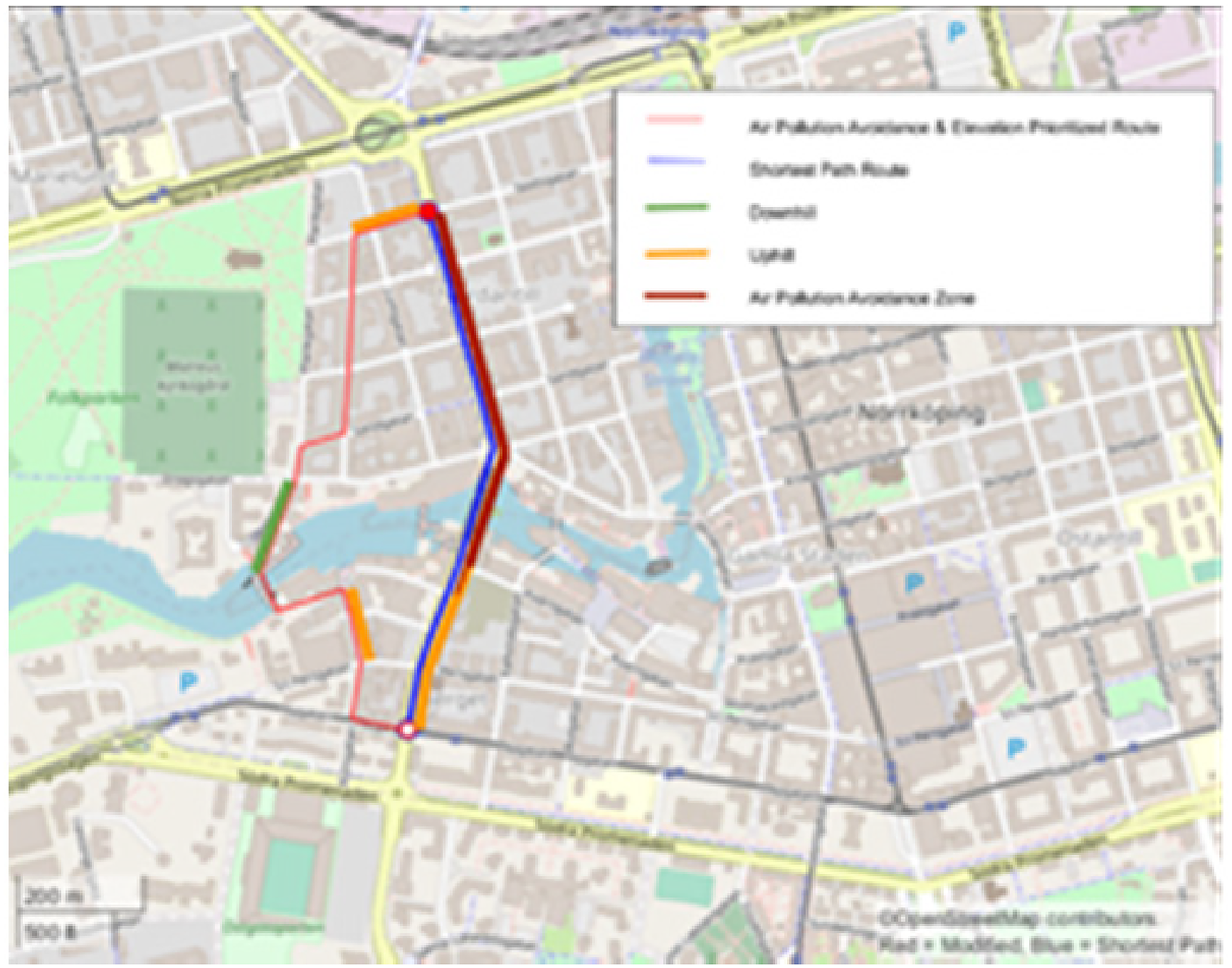
Elevation & air pollution avoidance prioritized versus shortest path for micromobility (Grachek, 2021: 39). With permission.
The sensors produce data that can be used to guide decision making of planners and citizens on appropriate and inappropriate uses of certain spaces. Shaw and Graham (2017a) suggest that new informational monopolies and platforms such as Google are rivalling the power of the traditional producers of conceived space, for example, planners and architects. Nevertheless, smart city technologies such as sensor networks continue to afford, and potentially extend, urban planners’ possibilities to produce conceived space and impose their visions of the city. There is thus a need to interrogate the assumed users and uses (Harrison, 2017) of sensor data, which are often overlooked when planning, constructing, deploying and analysing sensor data, and to explore how these ideas influence the use of the data. Similarly, it raises questions regarding sensor data's role in the relationship between conceived and lived space. While data can guide decision making in the planning department of city administrations, how people move around cities in their everyday lives depends on a variety of factors beyond the reach of sensors, which we will return to in the next section.
According to Lefebvre (1991) conceived space dominates the triad that produces social space and we could say that sensor boxes contribute to furthering this domination through its quantifications of space and everyday life. However, in the next section we want to go beyond this notion to explore sensor involvement in the production of lived space.
Lived spaces of smart cities?
Lefebvre (1991) stressed the focus on the contradictory, conflictual and ultimately political character of the three dimensions that produce space, and he saw possibilities for change in the moments that arise among the small changes in people's otherwise repetitive everyday lives. In this section, we want to explore the lived spaces that the sensors produce. However, it is important to remember that until now, the sensor boxes almost only enter lived space through the research team's experience of working with them. Nevertheless, constructing and deploying the sensor boxes along the testbed street gives rise to questions concerning not only how the sensor boxes relate to each other and other pieces of infrastructure, but also how they relate to the people inhabiting the city.
When working with the matrix one of the questions that appeared in relation to the street and people's everyday lives was if and how the sensor boxes enter lived space in a material sense. Are they mounted to be noticed, acted upon, or the opposite? While deploying them visibly could facilitate an understanding of their potential among the users of the street, placing them ‘out of the way’ could ensure their physical safety (similar concerns have surfaced in the Chicago Array of Things (Linn and Startz, 2016)). The particle sensor provides an example of this. One of the sensor boxes is placed within reach of people passing by and at one point, from one day to the other, the baseline measurements of this particle sensor changed. We do not know why this happened, but one possibility is that the air tube of the particle sensor was detached, potentially by exposure to some interference by people. If so, it would be one of the few times the sensors formed part of the lived experience of someone using the street. Another occasion when the box became visible was when we recently presented the project to the public and showcased the boxes. Besides showing the inside of the box, we could also point one out along the street, which seemed to excite people. Through the increased use of low-cost and DIY sensors for monitoring environments, there are currently attempts to democratize environmental practices that have until now been the domain of experts (Pritchard et al., 2018). In this sense, the visibility of the box can be a potential threat to achieving useful measurements while potentially being helpful in conveying an understanding of the possible uses of sensors and sensor data. This relates to ongoing debates about sensor technology and citizen sensing in transforming citizenship (Gabrys, 2014; Rose, 2020; Zandbergen and Uitermark, 2020).
The experience of someone potentially messing with the sensor box gives rise to several questions: could sensors be hackable, tweakable and the material for grassroots activism? Gabrys (2019a) has explored this by looking at how ‘how to’-guides and DIY toolkits for making your own sensors provide technical introductions for citizen-sensing as well as ‘
A related question concerns what impacts whether people will use the sensor data and how this could influence or potentially change people's habits. The way sensors and sensor data most likely enter lived space is through what they do, the data they provide and how that data (potentially) shows up in services that come to form part of people's lived experiences. Alternatively, sensors are experienced as variable depending on whether they are working smoothly or not, similarly to how infrastructure becomes visible when it breaks down or is under construction (Bennett, 2005; Graham, 2010; Star, 1999). Similarly, sensors might enter the lived experiences of people through the functions and spaces they are expected to deliver in the future. When sensor data, in that future, becomes widely available it is expected to help people navigate the urban environment, to improve people's health or be beneficial in other ways. However, changing behaviours are more complex than simply providing people with more information (White et al., 2019). Similarly, the concern with and lived experience of various urban problems varies between different groups of people, where, for example, particle levels in a trajectory might matter to some travellers more than others, where a cyclist might change route, but a car driver might not.
Returning to the issue of the potential for democratization of sensor technology, through our work with and reflecting around the sensors using the matrix, we have noted that sensors (and smart city technology) for the most part have developed in the conceived space of engineers and planners to then be deployed in perceived space, as is the habit of tech-driven processes. This can be read as a chronology in the matrix cell contents – what has been done/is being done/will be done. It thus seems that we can deduce directions from one space to the others in the matrix. Thinking about the matrix in a Lefebvrian sense, dialectically, could however enable us to read the matrix in a way that can reverse these directions for development, implementation and assessment of smart city technology. Starting technological development in lived space and moving towards the conceived and perceived spaces could potentially reverse the development cycle of smart city technology along the lines of reverse engineering. Would this lead to other types of smart city technology being developed and how would these then be?
What we have presented here is not an exhaustive mapping of the spaces produced by sensors and sensor data, but merely an attempt to indicate some issues around smart city technologies and spaces. By exploring the smart city through small but increasingly pervasive sensor technologies, we have tried to reach into more fundamental questions regarding technology's increasing involvement in the production of social space.
Concluding discussion
This paper explores how seemingly small objects such as sensors can have a large influence on the production of social space. Sensors measure and quantify certain data about space while rendering other types of data invisible and produce maps of the city and its problems that are partial, which is problematic. Sensor data is often perceived as providing a transparent and objective picture of the city space. Critical studies of big data by communication and digital media scholars such as Borgman (2015), Gitelman (2013) and Kitchin (2014) draw attention to the ways in which decisions about data management and virtual infrastructure constitute a form of knowledge production. Gitelman and others have drawn attention to a prevailing attitude that ‘data are apparently before the fact’ leading ‘to an unnoticed assumption that data are transparent, that information is self-evident, the fundamental stuff of truth itself’ (2013: 2). The examples that we offer here show how material challenges around developing and deploying sensor boxes may affect the data collected. The data and maps visualize and form the basis for urban planning decision making to solve identified problems. With partial maps we can however only solve partial problems and the solutions implemented can thus have unintended effects on diverse groups of people. Not only the (in)visibility of the data is therefore important, but also the (in)visibility of the sensors themselves. Deploying sensors visibly could contribute to showcasing their usefulness and trigger interest in the data they produce, by making sensors and their functioning tangible and potentially intelligible to citizens. At the same time, visibility can be a risk to the proper functioning of sensors and the accuracy of the data they produce. Our analysis shows that sensors and other smart city technologies thus warrant further investigation as to how they are increasingly involved in the production of smart city spaces and call for continued exploring of the interplay between the micro-scale of development and deployment of technology with their impact at the scale of the street, the neighbourhood, and the city.
The article further highlights the potential to reverse-engineer smart city technologies by thinking dialectically around their potential influence on diverse groups of people and urban spaces. While planners might see the benefits of implementing smart city technologies for decision making, these benefits still remain to be seen by other groups of stakeholders in order to overcome the risks of such technologies instilling feelings of command and control and turning citizens into ‘databodies in codespace’ (Mattern, 2018). Starting to think about what types of lived spaces smart city technologies might produce could be a first step towards such a movement towards reverse-engineering. Further, taking careful account of the lived spaces of smart cities could create opportunities for sensors to become mediators of needs and wants between different groups of citizens, or between citizens, planners, and others in loci of power.
Finally, this article illustrates how interdisciplinary research can approach complexity and thus contribute to analyze societal issues. By combining concepts and theory from human geography and science and technology studies – that is, Lefebvre’s (1991) theory of the production of space and Star and Griesemer (1989) analysis of how technology works in and across different contexts – with an empirical case of engineering we have used sensors as artefacts to explore the production of smart cities. This calls attention to further engagement among geographers with science and technology studies to explore the impact of (digital, platform and smart city) technologies on scales of human life ranging from the individual, the home, the street, the city, the region and the state to the global.